

NJ weather: Temperatures getting cooler, Ian forecast getting clearer
The Bottom Line
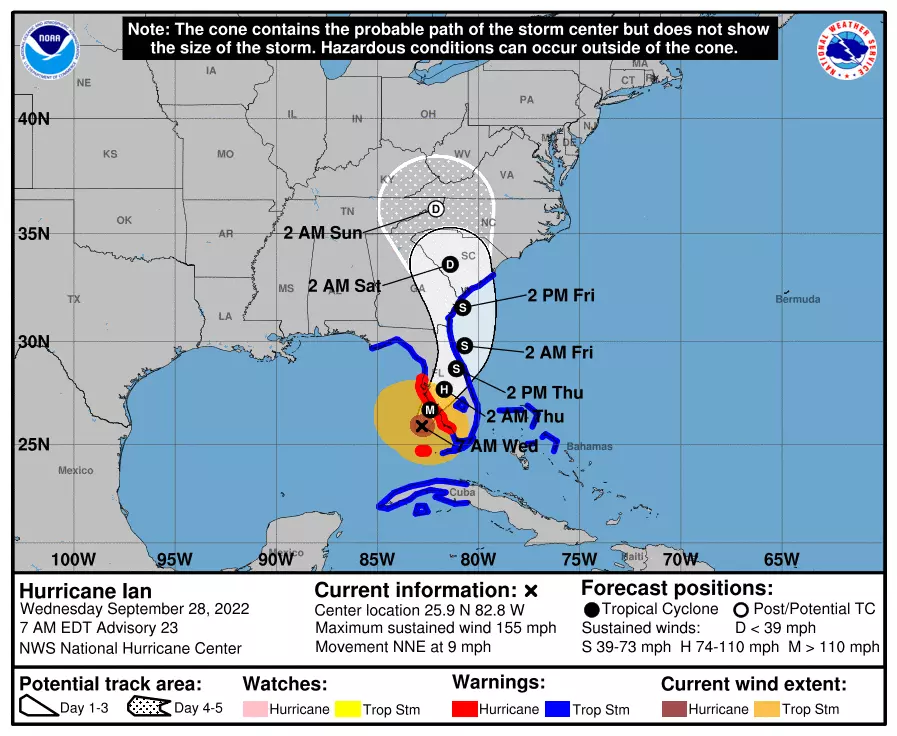
As of 5 a.m. Wednesday, Ian is a dangerous category 4 hurricane, with maximum sustained winds of 140 mph. The center of the storm was located just 75 miles from Naples, Florida. Landfall is expected Wednesday evening, with incredibly nasty weather conditions there both Wednesday and Thursday.
There have been two changes to Ian's storm track forecast since we last spoke. Number one, it's speeding up. Number two, the track has gotten "wavier". Ian's center is now forecast to briefly eject into the Atlantic Ocean before making another landfall around the Georgia-South Carolina state line. By this weekend, the once-powerful storm will be rapidly disintegrating over Tennessee.
That brings us to the New Jersey outlook, which is leaning far away from a worst-case scenario. We are going to feel some impacts from Ian. Heavy rain may lead to flooding of poor-drainage areas for part of the state. Part of this weekend may be inclement and even nasty. But truly dangerous? Not really.
Wednesday and Thursday will be fine. Clouds increase on Friday, and rain showers may bubble up into South Jersey. Saturday turns wet, then Sunday will be iffy.
Wednesday
Same story, different day. We're starting out Wednesday morning with a little chill in the air. Temperatures in the 40s and 50s may have you reaching for a jacket.
While Wednesday will start with abundant sunshine, clouds will likely build through the afternoon. It'll still be a dry, comfortable, and pleasant day overall. Look for highs in the upper 60s to around 70. Continuing the slow downward temperature slide that began last weekend.
Wednesday night will stay quiet. (Although some models put sprinkles over NW NJ in the evening hours due to a weak cold front, I think the air will be too dry for substantial raindrops.) Even with a blanket of clouds overhead, this cool dry air mass will still allow thermometers to dip to around 50 degrees by Thursday morning. More jacket weather.
Thursday
Another problem-free weather day. With a mix of clouds and sun overhead, high temperatures will get stuck in the mid to upper 60s. That is 5 to 10 degrees below normal for late September.
Friday
Here is when we could start seeing some minor impacts from Ian — or what's left of it — even though the storm's center will still be hundreds of miles away.
Ian's first impact on the Garden State: Clouds. On the northern edge of that storm system, Friday will progress from mostly cloudy to overcast. Initial cloud cover will probably be high-altitude, so we'll still get some filtered sunshine. High temperatures will hold steady in the mid to upper 60s.
Eventually, we'll see some rain bubble up into the southern half of New Jersey. For now, I believe those raindrops will hold off until Friday night.
The Ian Forecast
This is about the time that we can transition from "what the storm track might do" to "what the storm's impacts will be". As I mentioned, our outcome will be far from a worst-case scenario. But it won't be a total miss either.
Both the GFS and European models in particular show an increasingly wet day Saturday. Potentially a washout in South Jersey, with soaking rain traveling north by around midday. Rain could be heavy at times, leading to ponding and flooding of low-lying and poor-drainage areas. No wind yet, by the way.
Sunday is trickier. We could substantially dry out for the second half of the weekend. (Especially to the north.) But for now, I have to leave just-in-case showers in the forecast. The wind will also increase Sunday, with gusts between about 20 and 30 mph. (A far cry from the 140 mph in Florida, of course.)
Our weather may remain gloomy, windy, and damp Monday into Tuesday, as Ian's final piece of energy sweeps just to our south. Additional rain is possible, before sunshine and dry conditions emerge by about Tuesday afternoon.
Bottom line: Given the chance of rain, you will want to keep your weekend plans flexible. It looks inclement, but not catastrophic for the Garden State.
Of course, we will continue to update the anticipated timeline and impacts as the forecast continues to evolve.
Dan Zarrow is Chief Meteorologist for Townsquare Media New Jersey. Follow him on Facebook or Twitter for the latest forecast and realtime weather updates.
Every major Spirit Halloween location in New Jersey for 2024
Gallery Credit: Mike Brant
NJ school holidays with the biggest buzz
Gallery Credit: Erin Vogt
More From Lite 96.9 WFPG


