
NJ’s next storm system this weekend: Not all snow, but that’s bad news
As one snow storm wraps up, we have to keep our eyes on the horizon for the next one. And the next next one. And the one after that too. Hold your breath for one more week of active weather and cold temperatures, with at least three more substantial storm systems aiming for the Garden State.
Thursday: Wrapping Up
It's a winter wonderland across New Jersey on this Thursday morning. As of this writing (5 a.m.), anywhere from a healthy coating (north) to about 4 inches (south) of snow has fallen across the state. Road conditions range from barely passable to awful. And we have a number of schools and districts that have opted for a snow day, delayed opening, or full virtual day due to the weather.

Snowfall is already wrapping up in NW NJ. And we should see substantial improvements farther south between about 8 a.m. and 10 a.m. Final snowflakes are expected along the southern coast around Noon Thursday. Keep in mind, crews will not be able to get a solid handle on the roads until the snow stops falling.
A Winter Weather Advisory continues for most of the state until 10 a.m. or Noon.
The afternoon hours will remain cloudy and cold, with high temperatures only reaching the lower 30s.
Another weak disturbance will pass south of New Jersey Thursday night. At some point, a snow shower could clip far southern New Jersey — Cumberland and Cape May counties. But the geography and amount of any snow will be very limited.
Overnight low temperatures will dip into the teens — that's cold!
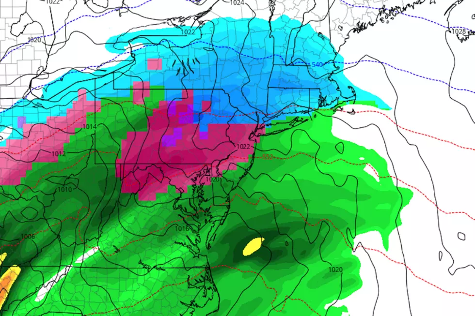
Saturday-Sunday: Snowy, Icy, or Wet?
After a quiet weather day Friday, another storm system enters the forecast for the weekend. And, as the headline of this post suggests, it's not going to be a big snow-maker, per se. Models don't paint a well-organized system. And the bulk of it should pass south and east of New Jersey. As the outlook stands now, we could see a few inches of snow accumulation, especially in North Jersey.
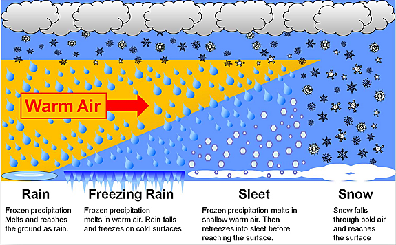
However, the greater concern is if the dominant precipitation type is sleet and freezing rain. An ice storm would be far worse than a snow storm.
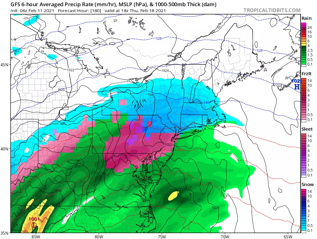
The reason for concern is a layer of warm (above-freezing) air about a mile above the surface — called a "warm nose" — above a layer of cold (subfreezing) air closer to the ground. As snowflakes fall through the sky, they melt into a water droplet in that warmer air. And then, if the cold layer is tall enough, the water drops will freeze into a solid ice pellet (sleet). Or, if the cold layer is shallow, the rain droplet will freeze on contact with a cold surface (freezing rain). Ice storms are horrible to forecast, and even more awful to experience.
The timing of this system is still a bit up in the air. First snowflakes, ice pellets, and/or raindrops would be in the Saturday afternoon-evening time frame. And things should wrap up sometime between Sunday morning and midday.
I do not see a big coastal flooding threat from this time at this time. But it's still something to watch, given at least a brief period of northeasterly winds.
We'll start to piece together a more specific precipitation type, accumulation, timing, and impacts forecast within the next day or so. No matter what flavor of "wintry mix" fall from the sky, things could easily get icy and sloppy for a good part of the weekend.
Tuesday: Another One?
After a quiet weather day Monday, our attention turns to yet another nor'easter-ish storm system from Monday night through the day Tuesday. This one will have some "oomph" behind it. Depending on which model you believe, it would have the potential of heavy snowfall and/or significant icing potential again too.
And that's all we can say about this storm for now. It looks like a strong "hit" (rather than a "miss") for New Jersey. And we'll continue to piece together those critical details around timing and impacts in the coming days.
Thursday: Grand Finale?
After a quiet weather day Wednesday (notice a pattern?), there is one more strong storm system signal in the queue around the Thursday time frame. Again, it's way too early for specific details. But this one will remain in the "worth watching" category.
Late next week, it looks like the active storm track will finally shift away from New Jersey. So I'm optimistic we'll have quieter, more seasonable weather heading into the final week of February. That's not a guarantee, of course. And there's plenty of "winter" left to come. But we could definitely use a break!
Dan Zarrow is Chief Meteorologist for Townsquare Media New Jersey. Follow him on Facebook or Twitter for the latest forecast and realtime weather updates.
COMPARE: Highest 2020 property taxes in each county
More From Lite 96.9 WFPG
