Wintry or just wet: Weekend storm timeline and totals for NJ
UPDATE... This article is outdated...
For the latest storm forecast information, please refer to my newest weather blog post.
The Bottom Line
There has been so much hype surrounding this weekend's winter storm. And some of that is justified. Most of New Jersey has been in a highly unusual snow drought for almost two years. And there is a legitimate shot at accumulating snow and messy travel conditions. But not for everyone.
Now that we are within 48 to 72 hours of onset, the forecast is firming up. And it is very clear that rain will be the predominant precipitation type for the southern half to two-thirds of the state.
There are still some questions surrounding the location and magnitude of potential snow accumulations. Because again, to the north and west, you may be reaching for a shovel by Sunday morning.
Let's run through the latest storm analysis. We also have to talk about some colder, blustery weather in the short-range outlook. And there is another big storm shaping up for the middle of next week.

For Now: Turning Blustery and Colder
Thursday morning is beginning with clouds. And some spotty sprinkles and flurries around. Very light stuff, that will not really get in your way at all. You might just notice some drops on your windshield or flakes flying around, through about early afternoon.
The sun will come out Thursday afternoon. But the day will turn breezy and blustery too, with potential wind gusts climbing to about 30 mph.
Morning temps are hovering around the freezing mark, in the lower 30s. Highs will be seasonable, in the lower 40s.
Thursday night will be quite cold, as thermometers dip well into the 20s. As the biting breeze blows, the wind chill (the "feels like" or "apparent" temperature) will easily end up in the teens. Not even close to record-breaking or dangerous cold, but you had better bundle up.
Friday will stay cold, despite sunshine. Highs will only reach the upper 30s.
Saturday morning looks cloudy with lower 40s. Then our storm system moves in Saturday afternoon.
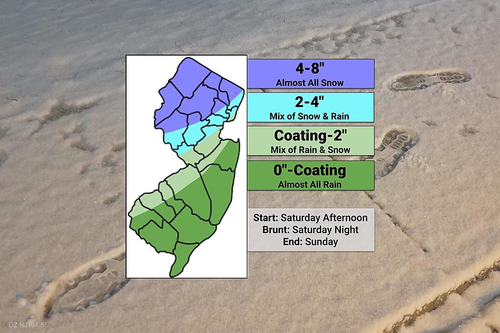
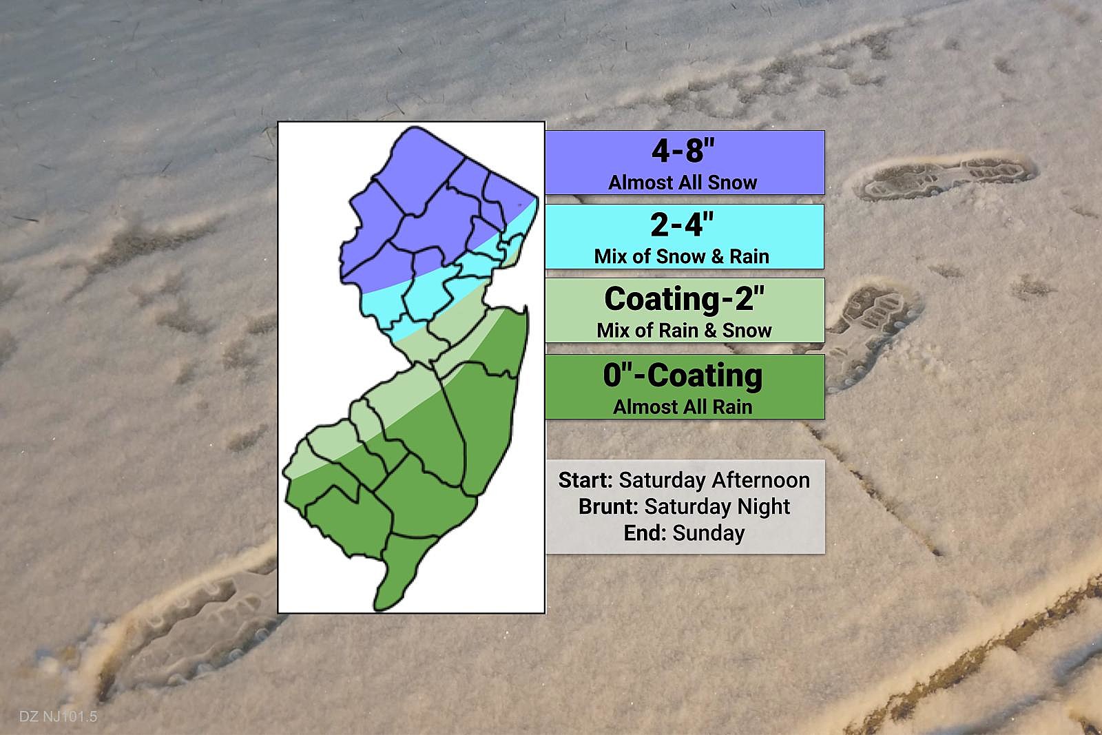
Storm Timeline
—Saturday Afternoon... Initial precipitation bands arrive from southwest to northeast. Onset will be mainly rain, especially south of Interstate 78.
—Saturday Evening... Heavier precipitation bands arrive between about 6 p.m. Saturday and 2 a.m. Sunday. In addition, more of central and southwestern NJ could flip from plain rain to wintry mix. Heavy snow could lead to rapidly deteriorating road conditions. Heavy rain could lead to ponding and flooding. This will be a good time to hunker down and stay off the roads, if possible.
—Early Sunday Morning... By daybreak Sunday, the intensity of precipitation should dial back considerably. It will feel breezy and raw. Precipitation type may gradually flip to mainly snow.
—Sunday Morning... While the brunt of the storm will be over, additional light snow (for most) and rain (south and coast) may linger throughout the day.
—Sunday Afternoon... All done.
Snow Accumulations / Rain Totals
—North Jersey... I have settled on a range of 4-8" of snow accumulation for the coldest segment of the state, subject to seeing almost all snow for the duration of this storm. The bullseye for a half-foot of snow will be centered on the "usual" spot — Sussex, Warren, and Morris counties.
—Route 1 Corridor... I think a few slushy inches of accumulation are possible between Trenton and Manhattan, on the order of 2 to 4 inches. I would call that "light to moderate' snowfall. But keep in mind, this is highly dependent on temperatures and how the rain-snow line wavers during the storm.
—NJ Turnpike Corridor... Down the I-295 corridor, I do think you will see snowflakes for a time Saturday night to Sunday morning. The question is whether those flakes can stick and accumulate on the wet ground. I have painted a hesitant Coating to 2" forecast from the Delaware Bay to the Raritan Bay, mainly on cold surfaces (cars, roofs, etc.)
—South and Coast... Hardly anything, as rain remains the predominant precipitation type. There's a chance for some mixing. And I could see a colder scenario that includes a brief period of snowflakes. So while I'm leaning hard toward a goose egg 0" snow total for coastal and southern counties, I have suggested up to coating (or dusting or trace) of snow is possible. Up to an inch of rainfall is likely.
Other Storm Impacts
Because the latest storm track brings the strong center of low pressure close to our coastline, gusty winds become more of a concern. Not necessarily damaging winds. But with gusts to 30 mph, the cold air will bite, and snow could blow around.
That east-northeasterly wind will also drive ocean water toward the coast. So we are watching the storm surge and coastal flooding potential very carefully. The ambient tide is relatively low right now, which is very good news — a lower starting point means a lower crest. But tidal guidance will start to give us a better idea of the potential flooding danger soon.
How Might This Forecast Change?
No weather forecast is complete without a measure of confidence — how sure the forecaster is that the prediction will happen.
I would call my forecast confidence "moderate" at this point. I think we have a good sense for the timing of this coastal storm, especially the start time (Saturday afternoon) and peak time (Saturday night). The wrap-up (Sunday) is less important as precipitation intensity will dial back significantly.
I will be watching four areas specifically for adjustment over the coming hours and days:
1.) That 8" max in North Jersey is a very rough estimate. I have seen other forecasts as low as 6" and as high as 12". I look forward to better pinpointing the location and magnitude of that "bullseye".
2.) The "battle zone" of Central Jersey is a real challenge here. (That is the light blue and light green areas on my map above.) I don't think model guidance has a firm handle on precipitation type yet. (And it may still be shaky even as the flakes start to fly.) At the moment, I'm leaning toward the lower end of those 2-4" and Coating-2" ranges. But we'll see what future model data looks like.
3.) Honestly, the 0"-Coating contour for South Jersey and the Jersey Shore will probably become a straight 0" at some point. This ain't your storm.
4.) The coastal flooding picture is precarious. Although I like the lower background tide leading into the storm, I'm still worried about a couple rounds of high water.
It is also important to note that the National Weather Service has held off on issuing a Winter Storm Watch for any part of NJ so far. That may change later Thursday. And we would not see warnings and (mainly) advisories issued until sometime Friday. Watch/Warning criteria is 6" in North Jersey and 5" in South Jersey. Advisory criteria is 3" and 2", respectively.
The Next Storm
That's right, there is not just one but two big storms in the forecast here.
The next one is currently forecast to impact New Jersey between Tuesday afternoon and Wednesday morning next week. Still outside of the 5 Day Forecast window, but definitely worth talking about.
Latest guidance suggests limited snow accumulation is possible in far northern New Jersey, above Interstate 80. But for the majority of the state, this looks like a heavy rain event. (Temperatures may come close to 60 degrees during the brunt of the storm.)
Total rainfall could end up around 1 to 3 inches for most of the state. That is enough to ring alarm bells for flooding once again. Especially since residual snow and ice on the ground would rapidly melt during heavy rainfall.
Next week's storm also looks like a fierce wind machine. Not only does that put power outages and wind damage on the table, but also coastal flooding once again.
Generally, it works best to focus our weather forecast on "one storm at a time". So we will continue to watch next week's super soaker carefully. But don't expect specific, confident details on timing and impacts until this weekend's storm wraps up.
Dan Zarrow's Top 10 Weather and Climate Stories of 2023
Gallery Credit: Dan Zarrow
Dan Zarrow is Chief Meteorologist for Townsquare Media New Jersey. Follow him on Facebook for the latest forecast and realtime weather updates.
First flakes: When does snow season start in NJ?
Gallery Credit: Dan Zarrow
More From Lite 96.9 WFPG