

Friday NJ weather: Goodbye storms and humidity, hello sunshine
The Bottom Line
This is it! Our big transition day is here. A cold front sweeps in thunderstorms Friday morning, and then sweeps out the humidity and unsettled weather. Leaving New Jersey with a fantastic weekend weather forecast.
Temperatures are going to ride a little roller coaster over the next week, with several rises and dips along the way. However, beyond Friday morning, things look primarily dry and storm-free for the next week at least.

Friday
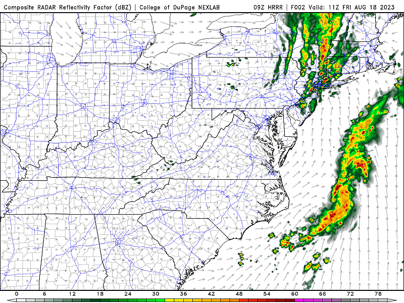
As of this writing (6 a.m.), a line of thunderstorms is charging across New Jersey. It will impact primarily the northern half of the state through 9 a.m. (Having said that, radar is picking up on a few showers farther south too.)
Those once-powerful storms do seem to be fizzling. So a quick burst of heavy rain and rumbles of thunder could interfere with your morning commute. But nothing too crazy.
The big question in Friday's forecast: How quickly will skies clear and humidity drop? My best guess: Very.
We should see partial sunshine statewide by lunchtime, becoming mostly sunny by dinnertime. While the chance of an isolated shower brushing past North Jersey in the Friday afternoon hours is not zero, I think dry conditions will prevail.
Speaking of dry, it is going to turn breezy if not windy Friday afternoon, with top gusts out of the west over 20 mph. That is the "whoosh" of our new air mass moving in.
Dew points will drop from 70s to 50s by Friday night, making the air feel much more comfortable. It will still be warm on Friday, with highs between about 80 and 85 degrees.
Friday night looks downright cool and crisp. The overnight low temperature will average 60 degrees, putting much of inland NJ in the 50s by Saturday morning. Not quite "sweater weather," but a marked change of pace from really sticky nights earlier this week.
Saturday
A beautiful day, from start to finish. Saturday will be one of those days where you want to spend as much time outside as possible, to breathe in the nice, fresh, clean, not-humid air. And give the air conditioner a break too.
Expect sunny, blue skies, dry weather, and dry air. High temperatures will end up somewhere around the upper 70s to lower 80s. That is a few degrees below normal for mid-August. But given the low humidity and especially the sun, I believe it will still feel warm enough for summertime activities like the beach, the boardwalk, the pool, the park, etc.
Sunday
Sunday will be the warmer day of the weekend. 60s in the morning. Mid to upper 80s in the afternoon. But humidity will stay nice and low, so you won't sweat too much.
We will probably see a few additional clouds build in Sunday, but I am still calling it mostly sunny. A light breeze out of the southwest will fuel the warmup. (A sea breeze will keep the beaches a few degrees cooler.)
Monday
Monday will be a one-day heat wave for New Jersey, as highs push into the lower 90s for most. Hot and sticky.
Having said that, it won't be entirely unpleasant. Especially since we stay out of the heat and humidity "danger zone". And since we will stay dry.
Clouds will increase on Monday, as winds remain light.
The Extended Forecast
There are two huge weather headlines that will dominate the United States next week.
First will be the impacts of Hurricane Hilary, striking Baja California this weekend and then impacting the Southwestern U.S. early next week.
Second, another massive heat ridge will build over the Central U.S. through the middle of the week. Potentially surging temperatures into the 90s and 100s up and down the Plains.
But here in New Jersey? It looks like smooth sailing, as we will be protected from that heat by a backdoor cold front arriving Tuesday.
There could be some showers around early Tuesday. And almost certainly cloud cover. But that influx of cooler air will knock back temperatures from the 90s to around 80 degrees.
And that is about where temperatures will stay through Wednesday and Thursday. By late-week, we may have some bursts of rain and thunderstorms back in the forecast.
5 Reasons The Jersey Shore Is Superior To Any Other Beach
Dan Zarrow is Chief Meteorologist for Townsquare Media New Jersey. Follow him on Facebook or Twitter for the latest forecast and realtime weather updates.
The Top 30 Roller Coasters in New Jersey
More From Lite 96.9 WFPG
