Tuesday NJ weather: Smoky haze, high fire danger, isolated thunderstorms
The Bottom Line
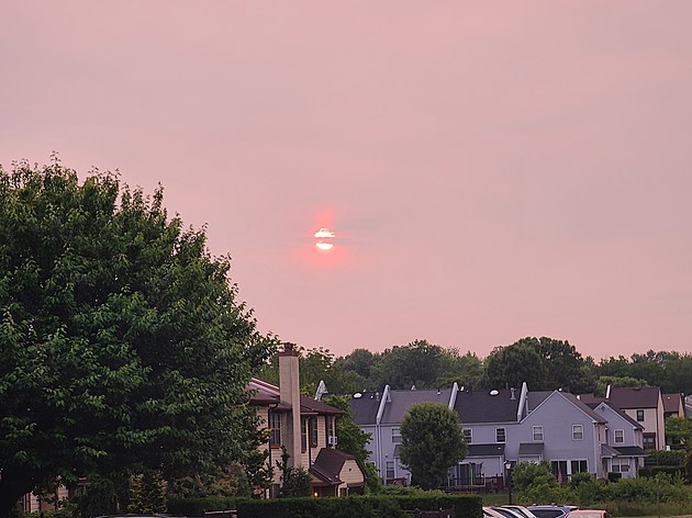
There are lots of unusual, interesting things happening in New Jersey's atmosphere Tuesday. The most prominent of which will be the return of smoky haze, this time stemming from raging wildfires over Quebec and Ontario in Canada. It's a bad scene there. And smoke is permeating the Northeast U.S.
Let's refresh the numerous weather impacts of smoke particulates in the atmosphere:
1.) A hazy, milky, washed-out sky.
2.) Extra vivid, colorful sunrises and sunsets.
3.) Temperatures may be tempered a bit.
4.) A persistent smoky smell in the air.
5.) Degraded air quality.
Our own wildfire danger is also running high, due to the classic combination of dry brush, low relative humidity, and windy conditions. Lightning is also a precarious factor in this forecast.
After Tuesday, temperatures settle at or below normal through the rest of the week. On the southwestern edge of an area of low pressure, we are technically somewhat unsettled — spot shower chances pop up Tuesday afternoon, Thursday, and Friday.
There is an opportunity for a healthy soaking and overall pattern chance early next week. But I will believe it when I see it.

Tuesday
First and foremost, it will be a warm and breezy day. We are averaging comfortable 50s starting out. And high temperatures will make a run for 80 degrees Tuesday afternoon.
It's definitely hazy to start the day. (The moon appeared a wild shade of red overnight.) Otherwise, clear conditions prevail for the morning, before scattered clouds roll in Tuesday afternoon.
The vast majority of the Garden State will stay completely dry. Having said that, a few popup showers and thunderstorms are possible, especially in the usual mid-afternoon through early evening time frame. I have to stress they will be very isolated — approximately the size of a town. So you might get a quick burst of rain, a brief roll and thunder, and that's it.
I do not think it will be quite warm or humid enough for severe thunderstorms (wind, hail, tornado) or flooding concerns.
Skies should mainly clear out Tuesday evening. And it will be comfortably cool through Wednesday morning, as thermometers bottom out around the mid 50s.
Wednesday
Wednesday is one of two "top-to-bottom, start-to-finish" beautiful days in the forecast. (Saturday is the other.)
Skies will be mostly sunny, although smoky haze may be an issue once again. In a slightly cooler, drier air mass, high temperatures will scale back to the mid 70s. Very nice.
Thursday
The late week period gets a little iffier, but there's still plenty of time for outside activities.
On Thursday, expect periods of sun and clouds. High temperatures will come down to the mid 70s — firmly below normal, but still feeling warm and comfortable.
The only big hiccup: A spot shower is possible on Thursday, especially in the afternoon.
Friday
Friday looks almost identical to Thursday. Mostly cloudy, chance of showers, highs in the lower 70s.
The Extended Forecast
I am becoming increasingly confidence that we will squeeze out a beautiful Saturday to start the weekend. Sun, clouds, dry weather, and mid to upper 70s.
Sunday potentially gets warmer and steamier, pushing back into the 80s. Most of the day looks fine.
However, model guidance is now picking up on an extended period of rain in the late Sunday-Monday-Tuesday time frame. The wettest solution puts about 2 inches of total rainfall, which would be wonderful given our recent dry streak.
I am not hanging my hat on that wet forecast just yet. And there are still question marks about what happens after that. (For the record, I'm leaning on more "classic" June weather taking over next week — warmer, more humid, and stormier in general.)
Just 15 days to go until the Summer Solstice.
LOOK: Highest-rated free things to do in New Jersey, according to Tripadvisor
Gallery Credit: Stacker
Dan Zarrow is Chief Meteorologist for Townsquare Media New Jersey. Follow him on Facebook or Twitter for the latest forecast and realtime weather updates.
Offbeat adventures: Travel to the coolest hidden wonders in every U.S. state
Gallery Credit: Sandi Hemmerlein


