
Nor’easter ramps up Monday: 12+ hours of heavy snow & wind for NJ
What is our current winter storm situation?
If you've been following along with my forecast, you know we're firmly in phase 2 of 4 of this complicated, high-impact, long-duration nor'easter. Even though the storm arrived faster and harder than expected on Sunday — with up to 7 inches of fast snow accumulation through Midnight (Hunterdon County) — my forecast timeline is back on track.
As of this writing, our classic "Miller type B nor'easter" is in the middle of its critical transition, transferring energy from the initial Ohio Valley low pressure to a developing low off the coast of the Carolinas. That is the one that will drive bands of intense precipitation and strong winds through New Jersey throughout Monday.
That process also causes some warm air advection. South Jersey has warmed to 40+ degrees. So we are seeing wintry mix and just plain rain for generally the southern half of the state. As temperatures crash again, at least part of southern NJ will flip back to wintry mix or snow by Monday afternoon. The only exception would be the immediate southern coast, which looks far more wet than wintry for the duration.
Winds are also starting to kick up, and we're coming up on our first of four precarious high tide cycles too.
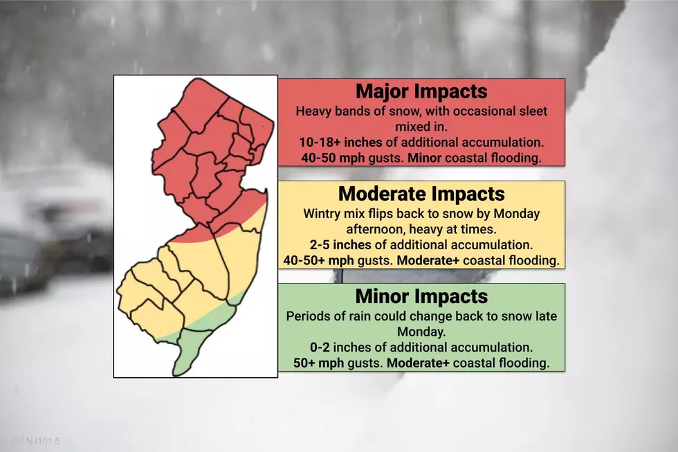
Do you have a new snow map to share?
No. My policy is to not issue "additional accumulation" maps for a snowstorm once it has begun. It's just too confusing, both to create and to explain such a product.
However, I did create an overall "impacts" map that hopefully gives a sense of what is expected through the rest of our nor'easter. These color contours are exactly the same as I presented in Sunday morning's weather blog post.
Winter Storm Warnings, Winter Weather Advisories, High Wind Warnings, Wind Advisories, Coastal Flood Warnings, and Coastal Flood Advisories remain in effect for various pieces of the Garden State.
When will the brunt, peak, or height of the storm be?
Remember, as of Monday morning, the worst weather is yet to come. To put a fine point on it, I expect the strongest wind gusts to blow through New Jersey between 5 a.m. and 7 p.m. The heaviest snow bands are expected between 10 a.m. and 10 p.m. Indeed, a full 12+ hours of wintry nastiness.
How bad will it get in the "Major Impacts" zone?
This will be the bullseye of the storm — not just for New Jersey, but likely for the entire Northeast U.S. As heavy mesoscale snow bands set up throughout Monday, snow will pour from the sky — rates may exceed 2 or even 3 inches an hour. (Thundersnow is possible!). Total snowfall will end up on the order of a foot or two across most of the area. Basically, take what's on the ground early Monday morning, and double or triple it to get a sense of the grand total.
The Bottom Line… If you don't have to travel, just stay put. Travel conditions will be awful all day.
Why is the yellow area only labeled "Moderate Impacts"?
As of this writing (6 a.m.) it is not snowing in that yellow area. Along the Interstate 295 corridor in southwestern NJ, radar is picking up on a wintry mix of snow, sleet, and rain. And along the southern coast (Ocean, Atlantic, and Cape May counties), it's just plain rain.
Eventually, slowly but steadily, temperatures will crash in the southern half of the state, enacting a return to wintry, mainly snowy weather. Probably by Monday afternoon accumulations will resume — I estimate anywhere from 2" (south) to 5" (north) are possible, on top of what's already on the ground form Sunday.
The Bottom Line… Conditions will vary widely by time and geography. Conditions will be sloppy in general, but not totally impassable (especially early on).
Does the green "Minor Impacts" area have anything to worry about?
Roads are in pretty good shape along New Jersey's southern coast, with temperatures in the 40s and just plain rain falling from the sky. Even so, a transition back to snow or wintry mix is not impossible late Monday into Tuesday. Therefore, let's not rule out additional light slush or snow accumulation, no more than an inch or two.
Even though the "wintry" weather will be limited, the wind and coastal flooding risks are especially high for Atlantic and Cape May counties.
The Bottom Line… It's wet and slushy, and things won't get much worse. Easy does it.
How hard will the nor'easterly wind blow?
The closer you are to the center of this powerful storm system (passing just east of New Jersey), the stronger the winds will be. Therefore, expect gusts to 40+ mph inland and 50+ mph along the coast.
Power outages are likely. Downed trees may block roads, further inhibiting travel. And visibility will be severely reduced due to the combination of wind and snow. Near-blizzard conditions are possible.
What is a Blizzard anyway?
Believe it or not, the technical definition of a blizzard has nothing to do with how much snow falls. A blizzard requires four elements:
1.) Sustained winds or frequent gusts of 35+ mph.
2.) Falling or blowing snow.
3.) Visibility less than a quarter mile.
4.) For at least 3 hours.
So it's about visibility and poor travel conditions, not necessarily snow accumulations.
Why are storm surge and coastal flooding so concerning?
Jersey Shore residents are well away of the flooding potential of strong coastal storms, like a nor'easter. The strong northeast winds will drive a big surge of ocean water toward our coastline. Tidal guidance is still holding steady at 2-4 feet of water rise, which is enough for moderate to localized major category flooding.
Making matters worse, the surge and surf will pound the Shore for 3 or 4 high tide cycles in a row — Monday morning, Monday afternoon, Tuesday morning, and Tuesday afternoon. Back bays and tidal tributaries are especially prone to flooding, as they won't be able to fully drain between crests. (The "low tide" on Monday and Tuesday will be closer to the usual high tide level.)
When will the madness end?
As I mentioned above, the snow and wind will lighten up noticeably Monday night, especially after Midnight.
But even as the coastal low pulls away from the coast, we'll see rounds of scattered snow through much of Tuesday too. Models differ widely in the intensity, accumulation potential, and timing of this final phase.
I'm leaning toward light snow tapering sometime Tuesday afternoon. An additional 3 or 4 inches of accumulation isn't out of the question at the tail-end of this thing.
What's next?
We'll finally see the sun again on Wednesday. With high temperatures above freezing, in the mid to upper 30s, let the snow melt begin!
Our next storm system down the road appears in the Fri-Sat-Sun. Forecast models have a poor handle on every aspect of this system right now. And I doubt that will change much until the nor'easter departs. One solution shows a substantial warmup, leading to a rainy solution for part of the weekend. However, if the warm air does not arrive, there could be some more accumulating snow to talk about in the coming week.
Regardless of what falls from the sky, another arctic blast is set to arrive behind that system for next week. Certainly a wintry and cold first half of February…
Our weather, traffic, news, and programming teams are camped out at the radio station to bring you the very latest information until the final flakes fly (and beyond). Thanks for following, be safe, stay warm, and enjoy the snow!
Dan Zarrow is Chief Meteorologist for Townsquare Media New Jersey. Follow him on Facebook or Twitter for the latest forecast and realtime weather updates.
COMPARE: Highest 2020 property taxes in each county
More From Lite 96.9 WFPG


