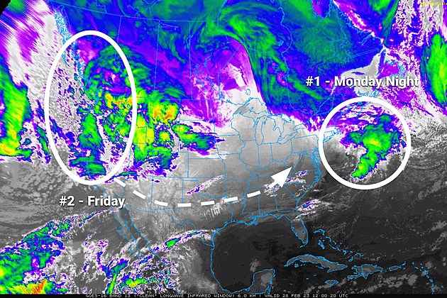
NJ weather: One messy storm exits, watching another for late-week
The Bottom Line
Well, there you have it — winter does exist in New Jersey. Snowfall totals from Monday night's storm ranged from zero in South Jersey to 6 inches around Sussex County in North Jersey. As promised, in the middle, we saw a mix of snowy, sleety, and rainy conditions. Roads through the northern 40 percent of the state are treacherous and icy, so be careful as the Tuesday morning commute begins.
As lingering showers exit, we will fall into quiet, mild weather. March will not start very lion-ish.
A quick burst of rain is expected Thursday morning.
And then we are watching another potential snowy, icy, rainy mess for Friday. This time around, it would be a daytime storm. With longer-lasting impacts than the last storm. But there are still a ton of question marks surrounding precipitation types, accumulations, and impacts.

Tuesday
Many spots in northern and central New Jersey experienced their first inch of snow of the 2022-2023 winter season overnight. Overall, I am pleased with how my forecast fared, in terms of snowfall totals, sleet potential, and road impacts on this Tuesday morning.
There are some icy, slushy roads across northern New Jersey. And if you're grabbing the shovel or snowbrush, keep in mind that snow is very wet and heavy.
The brunt of the storm wrapped up by around 2 a.m. Tuesday morning. But we're not quite done yet. There are light radar echoes stretching all the way back through Pennsylvania and Ohio. So you may still find some raindrops, snowflakes, and fog around until early Tuesday afternoon. Best chance for those showers will be across the northern half of the state. Little to no additional accumulation is expected.
Do not expect much sun Tuesday, until late afternoon at best. And temperatures will stay stagnant too — in the lower to mid 40s for most of the state. With fresh snow cover on the ground, North Jersey will be stuck in the 30s.
Quiet weather resumes Tuesday night, as skies finally clear. Low temperatures will dip to just below the freezing mark, around 30 degrees. Beware the refreeze — any leftover puddles or melt water could turn to ice overnight.
Wednesday
In the middle of a pretty active weather week, we will squeeze out a quiet, pleasant weather day. A rather non-lion-ish start to the month of March.
Expect partly sunny skies, a light breeze, and dry weather. (Worth noting, a few models do show a rain shower clipping far northern New Jersey around dinnertime.)
High temperatures will range from the lower 40s to the north, to the lower 50s to the south.
Thursday
A quick round of rain will slide across New Jersey Thursday morning, between about 4 a.m. and 10 a.m. There could be some fog around too, as temperatures rise.
The rest of Thursday looks fine. It will be mostly cloudy and breezy. High temperatures are trending about 10 degrees warmer than Wednesday. That puts highs in the lower 50s (north) to lower 60s (south).
Friday & Beyond
Our next potentially messy storm system is set to arrive on Friday. At almost 72 hours to go until it begins, details are still light. Here's what we know so far:
—There will be a storm. It will not be a total miss. And it will probably impact all of New Jersey in some way.
—Unlike the last one, this will be a daytime storm. Impacts are forecast to begin Friday morning.
—It will also be a more prolonged storm. Impacts may linger into Friday night and even Saturday morning.
—Cold air will be a problem again. So it's not a total snowmaker. Initial snow/ice/rain maps actually look very similar to Monday night's storm.
—Raw models are showing only light to moderate snow/ice accumulations, thanks largely to an expected transition to rain.
—Travel looks pretty messy again. The big concern will be Friday evening's commute.
We will focus much more on those timing and totals details starting on Wednesday. Then we will continue to dial in the forecast Thursday and early Friday.
What happens through the first weekend of March will depend heavily on how Friday's storm system plays out. I can tell you that next week looks fairly quiet — a nice change of pace after this potential double-whammy of winter storms for North Jersey.
Dan Zarrow is Chief Meteorologist for Townsquare Media New Jersey. Follow him on Facebook or Twitter for the latest forecast and realtime weather updates.
First flakes: When does snow season start in NJ?
Gallery Credit: Dan Zarrow
Final flakes: When does snow season end in NJ?
Gallery Credit: Dan Zarrow
Let it snow: 12 things to know about winter forecasting in NJ
Gallery Credit: Dan Zarrow


